Digital Twins are virtual replicas of physical systems that enable real-time monitoring, simulation, and optimization across various domains. By integrating data from sensors, IoT devices, and analytical models, Digital Twins provide a dynamic interface for understanding and managing complex systems. They have been in use by automobile and aerospace industries for a long time and have been a powerful tool to build a virtual model of the product for a variety of tests before a prototype is built. However, a Living Digital Twin is more than a 3D model or a simulation. It is an evolving, virtual representation of an object or process that uses data from, and observations of, its physical counterpart. A key advancement in this field is the incorporation of Geographic Information Systems (GIS), which enhances spatial awareness and contextual intelligence.
GIS-Enabled Digital Twins
GIS-enabled Digital Twins allow for precise GIS mapping and analysis, making them invaluable in urban planning, infrastructure management, utilities, and environmental monitoring. These systems not only visualize assets in their geographic context but also support predictive analytics and scenario modelling. By integrating GIS, IoT sensors and AI, these models mirror real-world systems like cities, utility networks, building indoors or natural landscapes with precise location context. Geospatial digital twins bridge physical and digital worlds, transforming raw spatial data into actionable insights for industries ranging from utilities to urban governance. As cities and industries evolve toward smarter, data-driven operations, GIS-enabled Digital Twins emerge as a transformative tool for decision-making and resilience. This paper explores the architecture, applications, and future potential of Digital Twins, with a focus on their integration with GIS technologies.

A Digital Twin is more than a 3D model or a simulation. It is an evolving, virtual representation of an object or process that uses data from, and observations of, its physical counterpart. Sensors enable analysis across a variety of metrics, typically enabled by a flow of data from its physical counterpart that is used to analyze, simulate and study the physical object.
Attributes of a GIS-enabled Digital Twin
Digital twins are being increasingly adopted across industries due to their ability to simulate real-world scenarios, optimize operations, and support data-driven decision-making. By integrating technologies such as IoT, AI, and GIS, digital twins offer a comprehensive view of assets and processes. GIS-enabled Digital Twins seamlessly integrate diverse spatial and non-spatial data, including BIM models, IoT sensor data, drone data, legacy data and real time feeds, all linked by location. They offer rich, interactive 3D, 4D (time aware) and even 5D ( cost aware) visualisation, allowing users to explore and understand complex systems intuitively. GIS-enabled Digital Twins leverage advanced spatial analysis tools to identify patterns, relationships and solutions in a geographical context. Ingestion of real time data from the physical world ensures that the digital twin reflects current conditions. It also enables the development of predictive models and scenario analysis.
ArcGIS for Digital Twins
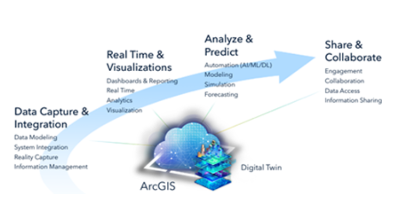
ArcGIS empowers organisations to create dynamic, data-rich virtual replicas of real-world environments. By integrating geospatial data, IoT sensor feeds, and 3D modelling, ArcGIS enables real-time visualization, analysis, and simulation of infrastructure, cities, and ecosystems. This enhances decision-making, predictive maintenance, and operational efficiency. ArcGIS is a cornerstone for building intelligent, responsive digital twin ecosystems. With its robust mapping and spatial analytics capabilities, ArcGIS supports the lifecycle of digital twins—from planning and design to monitoring and optimization. It is the foundation technology that supports the entire workflow from data capture and data modelling to simulation, prediction, sharing and collaboration.
ArcGIS Fuels Living Digital Twins

A digital twin brings together many adjacent yet distinct worlds. Central to a living digital twin is the 3D System, which provides clarity, new perspectives and connectivity to foster sustainable workflows for complex and evolving challenges. Digital twins are increasingly being adopted across industries due to their ability to simulate real-world scenarios, optimize operations, and support data-driven decision-making.
ArcGIS empowers organizations to adopt and mature digital twin technologies by integrating real-time sensor data, AI/ML, and advanced analytics. It enables dynamic virtual models that are descriptive, informative, predictive, and autonomous—supporting scenario-based simulations, remote inspections, and adaptive decision-making. These models are capable of simulating scenarios, forecasting outcomes, and making decisions with minimal human intervention. With 2D/3D visualizations and IoT integration, ArcGIS transforms physical assets into intelligent, connected systems for enhanced operational efficiency. ArcGIS based digital twins enable remote inspections, and adaptive operations, helping organizations transition from static representations to intelligent, self-learning systems. This comprehensive approach empowers users to optimize performance, enhance situational awareness, and drive smarter, data-driven decisions.
GIS-Enabled Digital Twin Applications
GIS-enabled Digital Twin applications are revolutionizing how we understand and interact with the physical world. By combining the spatial intelligence of GIS with the dynamic modelling capabilities of Digital Twins, these applications create highly detailed, real-time virtual replicas of physical assets, environments, and systems. This integration allows for advanced visualization, simulation, and analysis, enabling more informed decision-making in areas such as urban planning, infrastructure management, disaster response, and environmental monitoring. GIS enhances the contextual awareness of Digital Twins, making them more responsive and predictive. This capability is proving to be valuable across sectors.
This section explores the diverse applications of GIS-enabled Digital Twins, highlighting their role in fostering smarter cities, resilient ecosystems, and data-driven decision-making across industries.
Infrastructure
Digital Twins for infrastructure offer a powerful way to manage, monitor, and optimize complex systems such as roads, bridges, utilities, and buildings. By creating virtual replicas of physical assets, these models integrate real-time data from sensors, IoT devices, and GIS platforms to reflect current conditions and predict future performance. ArcGIS GeoBIM integrates GIS and BIM at the workflow level, adding context to the content. Digital Twin complements GeoBIM by creating real time replica of physical objects and enabling continuous monitoring, analysis and optimization.

A Digital Twin of a bridge can simulate traffic flow, detect structural issues, and assess the impact of weather or construction. Digital twins contribute in building virtual models to simulate stress response and identify vulnerabilities. As infrastructure ages and demands grow, Digital Twins provide a scalable, data-driven solution for sustainable development and lifecycle management.
Urban Transformation
Digital Twins are reshaping how cities are planned and managed offering a dynamic and data driven approach to create smarter, more sustainable and resilient cities. They are virtual replicas of physical urban environments that integrate real time data from various sources, including sensors, camera feeds, environment or weather data, and GIS maps powered by advanced spatial analytics. At the core of an Urban Digital Twin would be an Enterprise GIS platform hosting base maps, high resolution imagery, utility networks, et al.

The following are a few examples of how Digital Twins are impacting urban transformation:
- Urban Planning: Digital Twins create virtual models of proposed development – roads, buildings, green areas, public transport, amenities like schools, healthcare centres, recreation facilities, etc. and predict outcomes like traffic, environmental impact, etc. before physical implementation.
- Utilities: Digital Twins enable utilities to monitor and optimize operations by capturing real time data from sensors on water flow, pressure and quality among others. In electric utilities, they model load distribution and forecast demand. AI/Machine Learning help in analyzing patterns, predict failures and optimize operations. Digital twins offer a transformative approach to managing complex utility systems with greater agility, sustainability, and customer satisfaction.
- Traffic and Mobility Management: Digital Twins provide real time insights into traffic flow, facilitating simulations, predictive modelling and optimization of transport networks, leading to a reduction in congestion and improved mobility.
- Environment Management and Sustainability: Digital Twins can model environmental factors like pollution, air quality, heat islands, among others and are a powerful tool in the hands of city administrators to plan for climate events like floods, heat waves, etc.
- Emergency Response and Disaster Management: Digital Twins can simulate natural hazards like earthquakes, floods, or wildfires, aiding in risk assessment and emergency planning. Urban floods are emerging as a major challenge for city administrations. Digital Twins can play an enabling role in predicting floods and the development of mitigation strategies. They help in visualizing water flow, testing mitigation strategies, optimizing emergency response and support infrastructure.
Facilities Management
Digital twins are revolutionizing facilities management by creating dynamic, real-time virtual replicas of buildings and infrastructure. These models integrate data from IoT sensors, building management systems, and other sources to optimize operations, maintenance, and sustainability.

Key applications in facilities management are:
- Space Planning
- Dynamic, real-time monitoring of operations
- Predictive Maintenance
- Asset Lifecycle Management
- Emergency Response and Safety
- Energy Management
ArcGIS Indoors is a powerful indoor mapping and GIS platform that significantly enhances facilities management by providing spatial context, real-time data integration, and intuitive tools for managing indoor spaces. It enables organisations to create, visualize and analyse detailed indoor maps of buildings and campuses. It links all assets to precise indoor locations.
Agriculture
Digital Twins are revolutionizing farming by creating virtual models of fields, crops, and equipment. These digital replicas integrate real-time data from sensors, drones, satellites and machines to simulate, monitor and optimize agricultural operations. Digital twins support precision agriculture by enabling targeted irrigation, fertilizer inputs, and pest control. They also facilitate early detection of issues and informed decision-making. Key applications include:
- Crop monitoring
- Irrigation management
- Equipment maintenance
- Scenario Planning
- Sustainability
By enabling data-driven decisions, digital twins enhance productivity, resource efficiency and resilience in modern agriculture.
Tourism
Digital Twins can create virtual replicas of places of tourist interest to create an immersive experience for prospective visitors. They allow tourists to explore sites remotely before visiting and improve trip planning. ArcGIS can be used to capture high-resolution 3D models of tourist destinations—historic sites, natural landscapes, or urban attractions. ArcGIS ingests this data to build accurate, immersive digital environments. ArcGIS allows the creation of interactive 3D maps and scene layers that replicate real-world tourist spots. Digital twins can document and preserve endangered sites. ArcGIS supports temporal analysis, showing how sites evolve over time or under stress. Through web apps and mobile experiences powered by ArcGIS, tourists can interact with digital twins for guided tours.
Others
In addition to the above, Digital Twins are finding applications in several other domains also such as:
- Campus Management: Universities, manufacturing units, corporates can leverage digital twins to facilitate seamless movement of employees and visitors in the campus. They also enable real-time monitoring of energy usage, room conditions, and staff workflows.
- Airports: Digital twins in airports replicate terminals, runways, and operations using real-time data from sensors, cameras, and systems. They enhance passenger flow management, security, and maintenance by simulating scenarios and predicting disruptions.
- Manufacturing: Digital Twins can be used to optimize production lines, predict equipment failures and optimize operations.
- Safety & Security: Digital twins enhance safety and security by creating real-time virtual models of physical environments such as buildings, campuses, or urban areas. These models integrate data from surveillance systems, access controls and IoT sensors. Security teams can visualize vulnerabilities, monitor crowd movements, and optimize evacuation routes.

Conclusion
Digital twins represent a transformative approach to modelling and managing real-world systems across industries. By integrating real-time data, advanced analytics, and immersive visualization, they enable smarter decision-making, predictive insights, and enhanced operational efficiency. In sectors like urban development, infrastructure, agriculture, tourism, emergency response and disaster management, digital twins foster innovation, sustainability, and resilience. GIS empowers digital twins with spatial intelligence, transforming static models into dynamic, location-aware systems that drive smarter decisions and real-world impact. Their ability to bridge the physical and digital worlds positions them as a cornerstone of future-ready solutions.

Rajesh is Senior Director Strategy at Esri India with over 40 years of experience in the IT industry in India and overseas.