Planning
Bring smarter planning to bear for your community.
SUCCESS STORY
Tamil Nadu Highways uses ArcGIS for decision making in planning, programming, funding and allocation of resources allowing to make the best use of public funds in preserving the road networks at an acceptable level of serviceability.
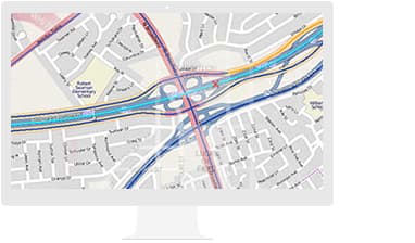
Gain a comprehensive view of your roads. This linear referencing system (LRS) solution enables departments of transportation to integrate data from multiple LRS networks.
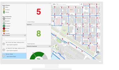
Know—in real time—where your assets and crews are. Apps for data collection, report generation, and workflow management give you a full view.
Explore and analyze data, and support data-driven decisions with powerful spatial analytics.
Road Asset Management System
Satra Infrastructure & Esri India collaborate to develop a GIS-based road asset management system HIMS Road Asset Management System stores, manages and analyses asset data (spatial and non-spatial) on Roads & Highways, structures, railways, power distribution lines, and any other linearly referenced features.

Use the power of GIS for greater insight and operational performance
Please fill out your details below for us to contact you for the demo.
Write to us at info@esri.in
Talk to us over the phone