Every expansion decision is a bet. But choosing a location for a retail business? That’s a different kind of endeavour altogether.
The process can be very exhausting. You need to calculate last-mile delivery routes, hourly footfall, infrastructure mix, transit times, parking, proximity to customers, and more.
Relying on guesswork for such a decision is too risky. This is where Geographic Information System, or GIS-driven retail location analysis, helps. It turns scattered signals into insights that help you compound business growth.
What is retail location analysis?
Retail location analysis is the process of analyzing geospatial and demographic data to identify business locations with maximum performance and profitability potential.
It is crucial in retail location analysis because it reveals relationships between data layers, including:
- Footfall patterns
- Income levels
- Competitor penetration
- Accessibility
- Zoning
- Logistics network
- Regional laws and policies
Analytical models not only find available spaces but also locations that align with a retailer’s long-term vision and target audience.
The complexity and dimensionality of data make manual analysis impossible. The analysis is typically done by retail location analysis tools that layer multiple datasets to predict how a site will perform across its lifecycle. With the right tools, multiple layers can be accurately analyzed at once to empower decision-makers to reduce risk, optimize investment, and plan rollouts that strengthen the entire store network.
For example, in India, ArcGIS® Business Analyst brings these insights to life with advanced retail location analysis that factors in multiple layers of data to map, visualize, and model location scenarios in real time. The result? Faster, more confident expansion decisions that turn location intelligence into a competitive advantage.
Now, let’s discuss this in detail:
How does GIS help in site selection?
Picking a retail location without GIS is like making a decision with half the facts, and it may cost you in the long run. This approach will likely lack necessary data points like credible footfall data, demographic stats, income overlays, consumer behaviour, traffic heatmaps, and competitor presence.
Here’s how GIS reveals the complete picture to help you select the perfect location for your retail business:
1. Traffic heatmaps
It’s not always about how many people pass by a site; it’s about knowing when they do it. A street may look busy at 8 a.m. due to a nearby corporate office, but might go dead by 6 p.m., right when your category for dinner peaks.
With GIS, you can uncover hourly, daily, and seasonal movement patterns. This way, you can pick the right locations that are busy when it matters most.
2. Demographic and Income Overlays
In retail, success hinges on truly knowing your customers and exactly where they are. A high-traffic area might look great on paper, but if it’s not where your customers live, work, or shop, it might be the wrong address.
GIS maps population density alongside income bands, household types, and age groups, revealing where the customers who fit your ideal profile actually live and spend. It’s the difference between casting a wide net and placing your store squarely in the path of the people most likely to walk in and buy.
3. Competitor proximity mapping
It’s crucial for your business to understand how your competitors perform in the area, where they are, and what command they hold in the target market. Retail store mapping using GIS can reveal exactly where your competitors operate, how their catchment overlaps with yours, and where there are genuine whitespaces to capture.
With GIS-based retail location analysis, it becomes easier to project acquirable market share, gauge intensity of competition, and test different scenarios to acquire new customers. All before you lock in your capital.
This way, you can triage your retail location on multiple benchmarks:
- Identify other locations for your retail brand
- Map 1st and 2nd degree competition by identifying suitable locations for businesses in the same category or industry
- Compare competitor presence across multiple geographies
- Identify threats and whitespaces by tracking competitor performance over a set period of time
4. Real-time catchment visualization
Every business needs to monitor its primary catchment areas where its target audience lives, works, or commutes. However, these areas are not static or immune to changes. Traffic patterns, weekend behaviours, and new infrastructure projects like metro lines can change them.
As localities continually evolve, planning in the absence of foresight might mean leaving your high-value customers outside your sphere of influence.
However, by running a GIS-based catchment analysis with a product like ArcGIS® Business Analyst, you can:
- Dynamically analyze multiple catchment areas using live traffic data across different routes and modes of transport
- Conduct a granular accessibility analysis against different modes, like driving, walking, or public transit, to see how and how many customers can reach you via what routes
- Integrate live population density from mobile and location data to track real movement patterns across different time periods
- Watch boundaries update instantly as conditions change through streaming data layers
As a result, you get a living map of your markets, telling you exactly where your customers come from and how reliably you can get to them, before you commit to a retail location.
Key factors to consider while choosing a retail location
Choosing a retail location means balancing regulations, access, visibility, competition, and cost. The right spot isn’t just convenient. It shapes customer flow, brand perception, and long-term ROI.
To break it down into a decision, here are some key factors that you need to consider while choosing a retail location:
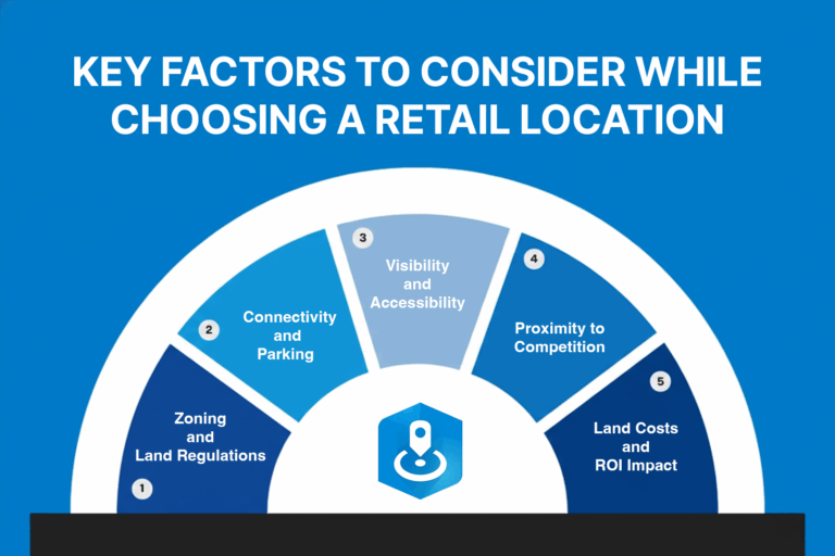
1. Zoning and Land Regulations
Zoning laws and regulations aren’t just red tape or procedural formalities, but they also set the operational perimeter for your business. They regulate the type of business activity in the zone, the architectural and functional attributes of a commercial building, and the safety codes it needs to meet. In other words, they can either unlock opportunities or halt some plans. Knowing them early can save sunk costs.
Here are some zoning and land regulations to consider:
- Land use restrictions: Verify if the site is zoned for commercial, mixed-use, or other retail-permitted categories
- Density and building codes: Understand limits on building space, height, and coverage to inform the layouts accordingly
- Special permits & variances: Factor in any special permits or approvals needed
- Conduct urban modeling: Visualize zoning scenarios in 3D to test compliance before committing
2. Connectivity and Parking
A retail site’s success also hinges on the level of accessibility. If one can’t get there easily, your location loses the competitive edge in comparison to other convenient options. This can be a game-changer, even if you have the right demographics or foot traffic.
Limited connectivity to key infrastructure networks like roads, metro stations, and parking spaces can choke customer footfalls. With GIS-driven analysis, this factor can be easily analyzed.
Here’s what you need to know:
- Gather traffic insights: ArcGIS Business Analyst can help you analyze vehicle, pedestrian, and bike traffic around locations, so you can pinpoint sites where movement naturally translates to visits
- Inventorize parking: Map and assess nearby parking lots and other facilities for parking to ensure adequate availability
- Visualize access points: Analyzing connectivity doesn’t end at roads; it’s about how people get to your site by foot and other modes of transport. GIS lets you layer in transit stops, metro stations, road networks, and pedestrian routes.
3. Visibility and Accessibility
Strong visibility and easy access turn passing traffic into paying customers. To make sure you’re visible to your target audience, here’s what you can do:
- Look for sites with high sightlines from roads or footpaths. It helps prospects see and recognize you from far away.
- Solve for ease of entry and exit, pedestrian access, and wayfinding. These help make your retail store feel approachable and welcoming.
- Align with transit routes and boarding stops to boost foot traffic and spontaneous visits
4. Proximity to Competition
Your competitors’ locations can either siphon away your customers or feed you new ones. The trick is knowing when to cluster and when to carve your own space.
- Visualize competitors nearby to decide whether you want to benefit from the environment or stand out solo in a location
- Keep a pulse on market saturation to avoid zones that can potentially dilute customer share
- Analyze the existing offerings in the area to optimize yours (e.g., a complimentary service or a fresh differentiator)
5. Land Costs and ROI Impact
The best location is all about the ROI it can bring, not just the base price on paper. Retail is a delicate balance between optimizing cost and revenue potential. Here are some key factors to consider to balance the ROI impact:
- For maximum ROI, you need the best deal on the land. Compare land prices across zones to align investment with expected foot traffic and revenue potential.
- Spot emerging zones of economic benefit using GIS, and secure your first-mover advantage
- Look at zoning limits, sales forecasts, and costs holistically through the lens of GIS before committing to a location
How can retailers use GIS to cluster customers and define catchment areas for maximum ROI?
GIS, or Geographic Information System, helps you see how your customers cluster, where they come from, and what predictable patterns drive their movement. They layer location data with customer demographics and purchase, mobility patterns to test scenarios that account for real-world conditions. These models adjust as new competitors come in to reveal how infrastructure and future investments reshape markets.
Here’s how GIS helps clustering customers and defining catchment areas:
- Pinpointing customer clusters: With clustering methods like K-means, density-based clustering, or hot spot analysis, GIS helps analyze high-value customer concentrations and segment them depending upon geospatial and behavioural data.
- Engage your high-value audience: It’s critical to analyze the areas that drive the majority of your sales. With drive-time analysis and a mobile location data map, you can actually figure out more about your primary audience. This can help you identify the right opportunities for concerted advertisement efforts.
- Find underserved markets: GIS-based retail store mapping can overlay demographics, spending power, and competitor locations to uncover high-demand areas with little to no retail presence.
Use case of retail location analysis with GIS in Indian Markets
Location intelligence offers a distinct competitive edge in India’s rapidly evolving marketplaces. Here’s exactly how ArcGIS Business Analyst can help retailers optimize their profits:
- Hyperlocal targeting: Identify high-footfall pockets near metro stations, malls, or office hubs for store launche
- Catchment and service optimization: Optimize service and delivery routes by analyzing customer origins using mobile location data
- Competitor proximity analysis: Inform your business strategy with highly accurate information about rival stores and how they impact the shared customer base
- Expansion planning: Detect underserved areas by overlaying demographic, income, and spending patterns with retail supply gaps
- Plan for surges: Anticipate demand surges near stadiums, exhibition centers, or seasonal marketplaces
With this level of insight, Indian retailers can align store placement with not only where demand truly exists but also where it’s headed.
Final thoughts
Retail is very competitive and crowded. Your direct and indirect competitors fight for the same consumer budgets and customer share. Yet, whether the business thrives or not hinges on strategic decisions like retail location.
For that, you need to know who your customers are, where they come from, how they move, how they spend, and what drives their needs and purchase patterns. Using retail location analysis products like ArcGIS® Business Analyst, you get the edge to pinpoint the right location with the strongest competitive advantage.
Written by
Esri India Marketing