Census of India 2027 represents one of the largest data collection exercises in the world, where technology plays a central role in ensuring accuracy, speed, and coordination. During the House Listing & Building Census (HLBC) phase, millions of households re surveyed, and data s collected digitally across diverse geographies. At the core of this massive operation ArcGIS Enterprise, enabling seamless data capture, service delivery, and integration across multiple administrative levels. However, running such a distributed and high-demand system required more than just deployment it required continuous monitoring and intelligent system management.
HLBC operations were not just large in scale they were complex and time sensitive. Thousands of enumerators were submitting data simultaneously through applications powered by GIS services. These services depended on multiple components such as web servers, databases, and network infrastructure. Even a minor slowdown in a service or a spike in resource usage could have impacted data collection in entire regions. Ensuring uptime and responsiveness, therefore, became critical to the success of the census.
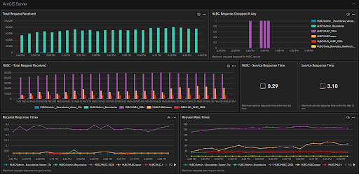
ArcGIS Monitor was configured with thresholds and alerts that continuously notified teams of anomalies such as high CPU usage, service latency, or system failures. These alerts ensured that issues were detected early, often before field teams experienced any disruption.
For example, during high-load scenarios in urban regions, alerts helped identify resource saturation on specific servers. Immediate corrective actions such as increasing instances or redistributing services were taken, preventing potential outages.
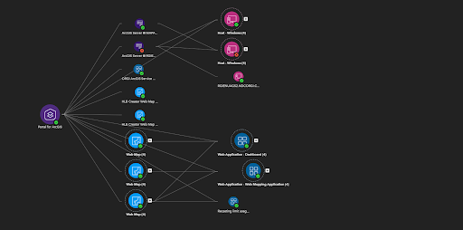
One of the most impactful capabilities used during HLBC was the visualization of system dependencies. ArcGIS Monitor’s component relationship graphs helped teams understand how different GIS assets such as services, databases, and applications were interconnected.
These graphs provide a hierarchical, tree-like representation of enterprise GIS components and their relationships, making it easier to identify upstream dependencies and isolate bottlenecks.
In the context of Census operations, this proved invaluable. For instance, if a particular feature service slowed down, teams could quickly trace which applications and districts were impacted. This significantly reduced troubleshooting time and ensured faster resolution during critical periods.
As HLBC operations progressed, ArcGIS Monitor accumulated a wealth of historical performance data. This data was actively used to analyse trends, identify recurring bottlenecks, and optimize system configurations.
For instance, patterns in peak usage times across states helped teams plan resource allocation more effectively for subsequent phases. This aligns with the broader use of monitoring tools in government systems to optimize infrastructure and reduce operational risks.
GIS solutions for state and local government help government organizations leverage geospatial technology to improve operations, support planning, and make informed decisions.
While the technology backbone was critical, its real impact was felt on the ground. Enumerators working in remote villages depended on responsive applications to submit data efficiently. A delay of even a few seconds could affect productivity and morale.
By ensuring system reliability through ArcGIS Monitor, the technical teams indirectly supported thousands of field workers. The smoother the system performed, the more efficiently data was collected ultimately contributing to the success of the census.
Census 2027 HLBC demonstrated that deploying a powerful GIS platform like ArcGIS Enterprise is only part of the equation. Ensuring its continuous performance at scale requires robust monitoring and proactive management.
With ArcGIS Monitor being actively used throughout the operation, teams were able to maintain high availability, quickly resolve issues, and adapt to changing demands. It transformed monitoring from a backend activity into a strategic function one that played a vital role in the successful execution of one of the largest administrative exercises in the world.
In essence, while enquerators collected the data on the ground, ArcGIS Monitor ensured that the digital backbone supporting them remained strong, stable, and always ready.
Abhinav Kumar is a Senior Analyst – Technical Services, specializing in GIS technology, enterprise solutions, and system performance monitoring to ensure reliable and efficient geospatial operations.