India’s 2025–26 grape export trade shows strong number with Agricultural and Processed Food Products Export Development Authority’s (APEDA) GrapeNet MIS data listing 33,136 registered export plots. These are spread across Maharashtra and Karnataka. These farms feed a trade with 60k+ MT across 4,370 containers to the EU, particular to Netherlands. GrapeNet’s strength is traceability, tying every consignment back to a registered plot and farmer. What it is missing is a map.
With nearly 176,000 hectares of grapes being cultivated, it is disheartening to see only 3,136 being registered as the plots that could provide export quality grapes. Most of India’s vineyards which serves Indian market are still not mapped. Indian consumers have hard time knowing the geographical awareness of the grape produce for and of India.
Mapping these grape fields could lead to Grape Map of India: a map that would have clusters of farmers, domestic suppliers, exporters, and packaging houses. A SAM-LoRA based Geospatial AI model can fill this gap by delineating grape fields from satellite imagery and generating grape farm boundary data. This foundational layer can then support the integration of farmer, domestic suppliers, exporters, packaging houses, and other grape value-chain datasets.
Grape farm delineation
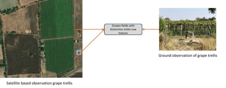
Grape farm delineation problem is a segmentation task. The distinctive trellis-row texture with the regular block spacing is the key distinctive feature of grape fields. Such pattern can be recognised from the very high-resolution satellite data (30 cm to 60 cm spatial resolution) as shown in the image below.
Segment Anything Model (SAM) by Meta, a foundational model, can be used to segment anything using zero-shot learning and generalise across domains. Though SAM segments all the objects, making it to segment only grapes farms on satellite data needs fine tuning of the model. This can be achieved by using SAM-LoRA, a variation of SAM, adds a set of trainable layers called Low-Rank Adaption (LoRA) to the frozen image encoder of SAM. Details of this fine tuning is given in link.
From Concept to Model
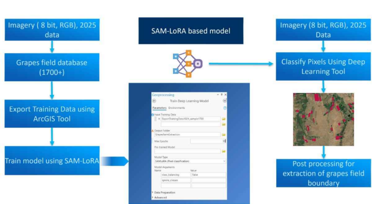
ArcGIS Pro provides easy to use tools, models and replicable workflows with respect to developing Geospatial AI models. Using SAM-LoRA based fine tuning is as simple as using any geospatial tools in ArcGIS Pro. Figure 2 shows the entire workflow for grape farm delineation. Key components of this workflow are
- Satellite Imagery with 8 bits, RGB and 30 or 60 cm resolution data.
- Digitized grape farms/fields for training the model.
- Data preparation and model training tools.
Specifics of satellite imagery play a key role. As SAM model is based on RGB, the input satellite data should be 8 bit RGB, and resolution should be of such order that distinctive trellis-row could be visible for the model. This is possible in sub-meter resolution data. Usage of lower resolution data such as that of Planet Scope, LISS IV or Sentinel-2 may not be good choice for accurate results. In such low-resolution data model cannot pick on the distinctive feature that grape farms have as seen from the satellite data.
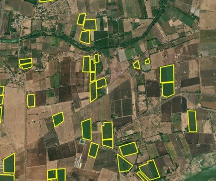
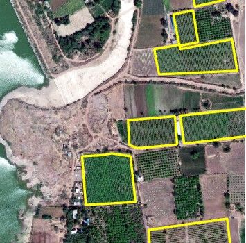
Providing the digitized polygon is another key aspect of training the model. Here in case, 1719 grape farm polygons which were identified by subject matter expert (as shown in the Figure 3) were used for training.
STEP 1:
These grape farm polygons will be used as input for data preparation using “Export Training Data for Deep Learning” tool. It should be noted that grape farm polygons should have a column that has class name and class value. Here in this case, “grapes” would be the class and “1” would be the class value.
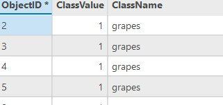
Once the polygons schema is set; use the Export training data tool to export the data for training the model. While exporting, chip size should be decided in such a way that at least 2 to 3 grape farms could be visible in the chip (as shown in Figure 4). This is possible with 1024-pixel size chips.
STEP 2:
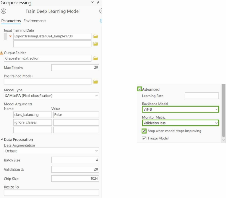
Training of the SAM-LoRA is done using the “Train Deep Learning Model” tool. For Backbone Model, choose ViT-B where B stands for “base” and a default one. This option will train the SAM-LoRA model on a smaller (base) backbone model. There are other 2 backbone models vit_l, and vit_h, these should be chosen based on the availability of the hardware resources. Figure 5 shows the Train Deep Learning Model tool and parameters used during the training.
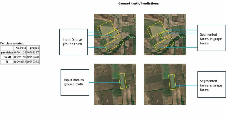
Model trained using SAM-LoRA, called as GrapeFarmExtraction model gives as F1 score of nearly 0.95 for segmentation of grape farms in the region. Model was able to segment the grape farms as shown in the Figure 6.
STEP 3:
The generated model, a .dlpk file, would then be used to delineate the grapes farm using Classify Pixels Using Deep Learning tool. The output of the tool would be classified raster with pixels representing grape farm. Post processing involving vectorisation and polygon smoothing should be done to get grape farms in the polygon format. These delineated grape farm polygons could be further used in the workflow involving cluster mapping, importer-exporter mapping, traceability, health monitoring using Sentinel-2 data, yield estimation becoming foundational layer that supports grape value-chain.
Conclusion
ArcGIS Pro offers a straightforward, tool-based workflow for SAM-LoRA based grape farm delineation. Very high-resolution satellite imagery, combined with ground-truth polygons, is essential for developing an accurate grape farm delineation model. With ArcGIS Pro’s LoRA fine-tuning approach, adapting SAM for grape farm segmentation in very high-resolution satellite imagery becomes more practical and accessible for the horticulture industry.

Shivaprakash Yaragal, Senior Analyst-GeoAI, designs India specific GeoAI solutions for Esri India Customers.