Disposal of waste from urban setting has always been big challenge from the time of first urbanisation. This problem persisted in Harappan civilization, in Roman period, during industrial age and is still present in 21st century. Each era has its own way of dealing with this problem. Harappans built underground drainage system, Romans introduced wagon-based waste collection system to name a few.
21st century Indian cities are urbanizing at a rapid pace. It is a big challenge for every city. Varanasi, being one of the oldest living cities in the world, has its own myriad of issues related to high urban density, congestion, and both leading to decreased efficiency of solid waste collection.
Varanasi Smart City
Smart City Mission, a flag ship program of MoHUA, identified solid waste management as the major issue of Varanasi Smart city. Smart City Mission divided the issue into 2 parts, first at administrative level and second at user level. To resolve these issues Varanasi Smart City adopted Esri Technology.
The main objective of enabling GIS was to have real time integration IoT (status of filled waste bins) and maps. This integration would be monitored both at bin level and at ward level (aggregation at ward level). This integration would bring
- Efficient administration in planning
- Route planning for waste bin pick up
- Establishment of waste processing unit based on type of waste
ArcGIS server (as shown in figure 1) is the important component of current deployment in Integrated Command and Control Centre (ICCC) of Varanasi Smart City. An ETL (Extract, Transform and Load) process was designed to ingest REST APIs (from the sensors) and create map service. These services were then used to create applications that are working as decision support system for city administration.

Key Features
The Key features of the application created for the solid waste management are as follows:
- An application (Figure 2) with real time visualization of the bin fill status of the Smart Bins has been deployed. Bin status gets updated on periodic basis. Status is marked by 3 colours. Red for reaching threshold of 80% fill, yellow for below 80% and green for unfilled bins. With such real time status updated, Varanasi Smart City can optimise their resources in picking up the wastes and its disposal. Interactive filters have also been set up to help the users explore data Zone wise and Ward Wise.
- Application also has an administrator console where admin can see the aggregate waste generated in each of the wards, and route taken by vehicles to collect the waste. The Chart widget has been configured to observe possible patterns and trends present in the data.
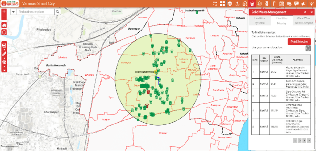
- The application has also been configured to find the nearby bins and find the route to it (Figure 3). This capability uses ArcGIS Network Analyst extension of ArcGIS server to perform the activity.
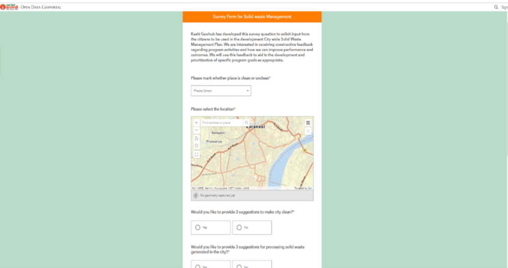
- The citizens are key stakeholders of the solid waste management. They would like to have tools to notify the administration about the garbage locations. To address this, Kashi GeoHub was configured using ArcGIS Hub. A simple and intuitive form-centric data gathering solution (Figure 5) has been designed using ArcGIS Survey123 to gather the information about the solid waste problem in the Varanasi. A dashboard to monitor these submissions has been configured using ArcGIS Dashboards.
-
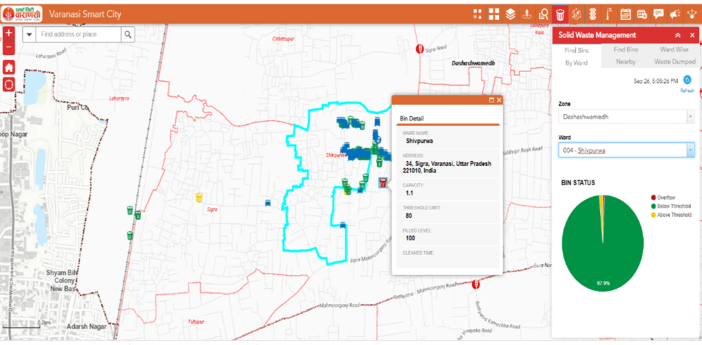
Figure 2 : Bin Fill Status application

Conclusion
ArcGIS Platform supports the cities to undertake the sustainable waste management system, by putting up layers of information like street maps, Buildings, and existing bins. It defines zones to undertake the waste management. The GIS data of buildings are used to map the door-to-door waste collection strategy. GIS strategy helps in identifying secondary garbage disposal points and landfill sites based on a set of natural parameters and development parameters. Thus, GIS based Platform brings a great level of efficiency in planning waste management system of the cities, thereby helping cities to move towards becoming a smart and sustainable city.

As the Urban Presales Head, I design GIS solutions for Urban Planning Development and Management.