In a location-driven world, understanding terrain is essential, whether you’re planning infrastructure, assessing environmental risk, optimizing visibility, or building 3D experiences.
Esri provides a variety of tools for terrain insights. This blog focuses specifically on the Elevation Analysis Geoprocessing tools – Profile, Viewshed, and Summarize Elevation. Esri offers ArcGIS Elevation Geoprocessing Tools that provide a scalable approach to terrain analysis, eliminating the need to manage large datasets or maintain specialized local infrastructure.
Why using Elevation Analysis Tools?
Eliminate the Data Burden
High resolution elevation data can easily run into terabytes. Acquiring, maintaining, updating, and optimizing these datasets is costly, time consuming, and technically demanding.
Elevation Geoprocessing Services remove this burden entirely. The elevation data is pre‑processed, curated, and optimized by Esri, allowing organizations to start analysing terrain immediately without worrying about storage, data preparation, or performance tuning.
Business value: Lower infrastructure costs, faster time to insight, and productivity that scales across teams.
One Source of Truth Across the ArcGIS Ecosystem
The services work seamlessly across ArcGIS Pro, ArcGIS Enterprise, and ArcGIS Online. Planning, engineering, operations, and leadership all work from the same terrain insights, thus, no rework, no duplication, no conflicting answers.
Ready for Real-World Use Cases
Elevation data is foundational to many real-world applications, including:
- Infrastructure and Utilities: Line of sight analysis, route planning, and site selection
- Environmental and Disaster Management: Flood modelling, watershed analysis, and landslide risk assessment
- Urban and Regional Planning: Development suitability and visual impact assessments
- Defence and Aviation: Visibility analysis, terrain awareness, and operational planning
Ready-to-use tools like Profile, Viewshed, and Summarize Elevation deliver these without custom workflows.
Built for Security and Enterprise Control
For organizations with strict data governance requirements or limited internet connectivity, Elevation Geoprocessing Services can run entirely inside ArcGIS Enterprise. Data and processing stay within controlled infrastructure which is well suited for government agencies, utilities, and compliance-driven enterprises.
Using Elevation Analysis Tools
Elevation geoprocessing tools Profile, Viewshed, and Summarize Elevation are available.
Profile
The Profile tool allows you to create profiles of your choosing anywhere on the surface of the earth.
An elevation profile shows you the height (or depth) of a surface along the length of a linear feature. It is an effective way to visualize and understand the elevation and topography of the surface of the earth.
There are two Profile tools available, one in the Elevation toolbox and the other in the ElevationSync toolbox. Profile Tool in Elevation toolbox is asynchronous task, designed for long-running tasks, such as batch processing a large number of profile lines at once from a single input feature class. It allows a maximum of 1,000 input line features at a time. Profile Tool in Elevation Sync toolbox is synchronous task, which is designed for interactive profile applications, which typically have fewer input lines and require a faster response. It allows a maximum of 100 input line features at a time.
Use Profile Tool in ArcGIS Pro
To create Profile in ArcGIS Pro, connect to ArcGIS Enterprise where you have published the geoprocessing service.
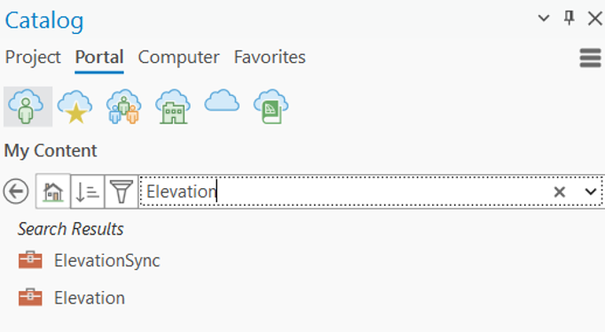
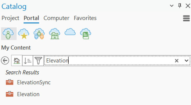
1. In ArcGIS Pro Catalog Pane, click on Portal and search for Elevation and ElevationSync
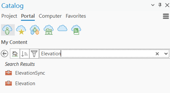
Note that there are two Profile tools available. Elevation is for asynchronous applications and the ElevationSync is for synchronous ones.
2. Click a Profile tool to open the tool dialog box.
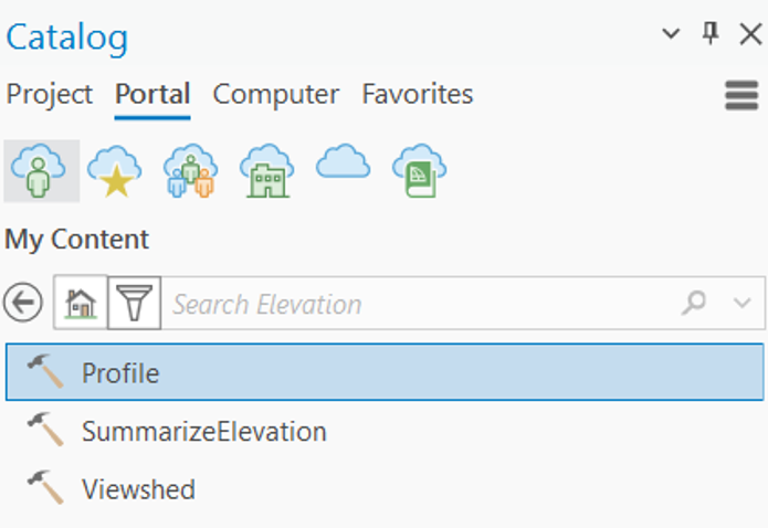
3. Specify the line for which you want to create the profile and set the other parameters as you prefer.
- Input Line Features: The line feature for which you are creating a profile.
- Profile ID Field: A string or integer unique identifier to tie profiles to their corresponding input line features.
- DEM Resolution: The approximate spatial resolution (cell size) of the source elevation data used for the calculation. (Default is 90m)
- Maximum Sample Distance: The maximum sampling distance along the line to sample elevation values.
- Maximum Sample Distance Units: The units for the MaximumSampleDistance. (Units in Meters | Kilometers | Feet | Yards | Miles)
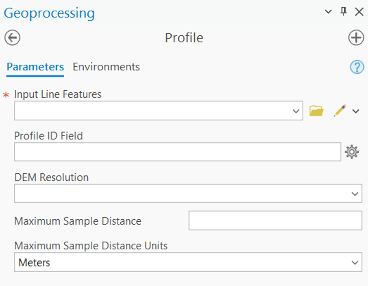
4. Click Run to run the tool. The result is added to the table of contents of the current map as a feature layer.
Viewshed
The Viewshed tool returns visible areas for a given set of input observation points.
The purpose of viewshed analysis is to identify visible areas. You specify the observer locations you are interested in, either from a dataset or interactively, and the Viewshed tool combines this with terrain data to create output polygons of visible areas, the areas that can be seen from the observer locations.
Use Viewshed Tool in ArcGIS Pro
To create Viewshed in ArcGIS Pro, connect to ArcGIS Enterprise where you have published the geoprocessing service.
1. In ArcGIS Pro Catalog Pane, click on Portal and search for Elevation toolbox.
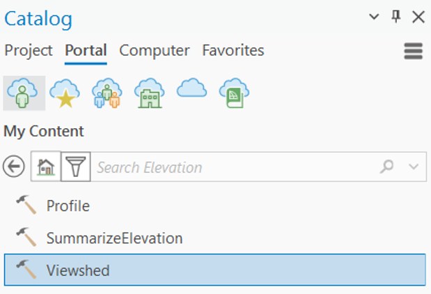
2. Click on Viewshed tool to open the tool dialog box.
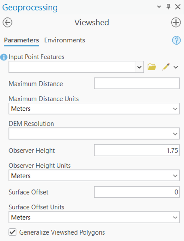
3. Specify the input points for which you want to create the viewshed and set the other parameters as you prefer.
- Input Points: The point features to use as the observer locations.
- Maximum Distance: The maximum viewing distance of the observers.
- Maximum Distance Units: Specifies the units for the Maximum Distance parameter. (Meters | Kilometers | Feet | Yards | Miles).
- DEM Resolution: The approximate spatial resolution (cell size) of the source elevation data used for the calculation. The default is 90m.
- Observer Height: The height above the surface of the observers. The default value of 1.75 meters represents the height of an average person. If the observers are looking from an elevated location such as an observation tower or a building, use that height instead.
- Observer Height Units: Specifies the units for the Observer Height parameter. The default is meters. (Meters | Kilometers | Feet | Yards | Miles).
- Surface Offset: The height above the surface of the objects you are viewing. The default value is 0. If you are viewing buildings or wind turbines, use their height.
- Surface Offset Units: Specifies the units for the Surface Offset parameter. The default is meters. ( Meters | Kilometers | Feet | Yards | Miles).
- Generalize Viewshed Polygons: Specifies whether the viewshed polygons will be generalized. The viewshed calculation is based on a raster elevation model that creates a result with stair-stepped edges. To create a more pleasing appearance and improve performance, the default behavior generalizes the polygons. This generalization will not change the accuracy of the result for any location more than one-half of the cell size corresponding to each DEM resolution.
4. Click Run to run the tool. The result is added to the table of contents of the current map as a feature layer.
Summarize Elevation
The Summarize Elevation tool calculates summary statistics for features you provide based on the elevation in Terrain data. It accepts point, line, or polygon input and returns statistics for the elevation, slope, and aspect of the features.
Use Summarize Elevation Tool in ArcGIS Pro
To Summarize Elevation in ArcGIS Pro, connect to ArcGIS Enterprise where you have published the geoprocessing service.
1. In ArcGIS Pro Catalog Pane, click on Portal and search for Elevation toolbox.
2. Click on Summarize Elevation tool to open the tool dialog box.
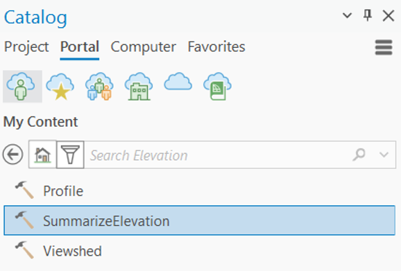
3. Specify the input features (points, lines, or polygons) for which you want to calculate elevation statistics and set the other parameters as you prefer.
- Input Features: The input point, line, or area features for which the elevation will be summarized.
- Feature ID Field: The unique ID field to use for the input features.
- DEM Resolution: The approximate spatial resolution (cell size) of the source elevation data used for the calculation. The default is 90m. The available values are FINEST | 10m | 30m | 90m.
- Include Slope and Aspect: Specifies whether slope and aspect values for the input features will be included in the output in addition to the elevation values.
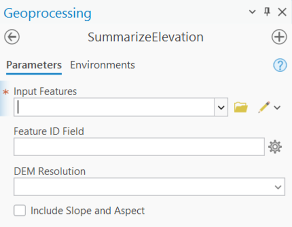
4. Click Run to run the tool. The result is added to the table of contents of the current map as a feature layer.
Final Thoughts
Elevation data is complex. Using it shouldn’t be.
ArcGIS Elevation Geoprocessing Services offer a modern, scalable approach to terrain analysis that cuts operational overhead while improving accuracy, speed, and consistency. For organizations that depend on location intelligence, it’s not just a capability but a strategic advantage.

As Product Lead, Geetesh focuses on Esri India Data Products, including Indo ArcGIS Living Atlas, Basemaps, and StreetMap Premium.