research paper

RESEARCH PAPER

Nature-based Solutions for the Unaltered Ecosystems

Addressing Vacant Lands as a Typological Study in Ahmedabad through GIS Methods

Abstract

Nature-based solutions (NBS) are increasingly recognized in the 21st century by promoting ecological resilience amidst climate change. Unlike traditional engineered infrastructure, which often neglects ecological services, NBS offer co-benefits by integrating natural ecosystems into urban planning strategies. In a semi-arid climate, Ahmedabad, India, faces challenges exacerbated by rapid urbanization, leading to increased heat stress and compromised environmental quality. To address these issues, this research leverages GIS methodology to identify and prioritize vacant lands as a typology to implement NBS, thereby enhancing ecological functions within the city. 

The study utilizes GIS to analyze spatial data, focusing on vacant lands that have deteriorated from vital open spaces to stressed environments with reduced water retention capacity and increased runoff during monsoons. By overlaying high resolution satellite imagery (LISS-IV band set of 5.8m grid resolution) with flood point datasets and contour maps, the research employs supervised image classification to categorize land use classifications. The processing through GIS facilitates the identification of critical vacant lands in the city through a graded grid-rank by a 1km x 1km scale f ishnet for statistical raster calculations.

The analysis identifies priority areas where NBS interventions can be most effective for proposing a matrix of solutions catering to different levels of vacant land stress. In conclusion, the research underscores the relevance of NBS as a pivotal strategy for mitigating urban environmental challenges by using applicable GIS methods to identify, rank, and analyze city-level conditions relevant to vacant lands as a typology.
 

Introduction

In the 21st century of modern growth, globally cities and societies are facing climatic challenges that are leading to precipitous changes or in some cases, irreversible environmental changes (Brears, 2020). Globally, cities are expanding at exponential rates over the past few decades. Higher population prefers living in urban areas because the metropolis is a crucial center of markets and development opportunities. On the parallel, excessive water withdrawal, loss of vegetation and tree cover, and pollution are a few to name that are results of rapid urbanization on the climate. The need to expand and occupy land for human interventions has altered the terrain, its natural positioning of functions, and related ecology.  

Contextualizing the case of urbanization and climatic extremities, Indian cities have always been a result of landscape expansions that have not prioritized ecological settings within neighborhoods through planning. In specific, Ahmedabad in western India falls under the hot-semi-arid climatic zone. The city experiences hot and humid weather with scorching summers exceeding 40°C while winters are mild and dry. A recent study conducted at CEPT reveals that people of Ahmedabad experience heat almost 331 days out of the entire year (Shastri, 2023). The city holds a population of about 8 million within 190 square kilometers of the area under the Ahmedabad Municipal Corporation (AMC) limits. The city’s built-up area has increased to about 72% from merely 81.68sqkm in 2005. While the city has been expanding at higher rates in the peripheries, several attempts to include environmental developments have been carried out in master plans, one such example being the green belt. However, these did not respond to the market trends and ownership compliances, and proposals have not been fruitful in the development schemes, eventually ending up as highways instead.  

In specifics to tree cover and vegetation, there has been a tremendous drop in the tree cover, to only 24%. Concerning public green spaces, AMC maintains about 200 parks, although comprising to regular maintenance in only 4.09% of the sum. Such parks and open spaces, mostly follow a standard design, predominantly being ornamental or manicured landscapes. Looking at vacant lands of the city, these have become spaces that hold public activities like play spaces, large gatherings, and festivities, however have been degrading due to excessive dumping, poor maintenance, and surrounding environmental concerns. 

Especially in the context of a semi-arid zone where water is seen as a prized possession, the need to tap into the topographical setting is a prime goal to revive ecological functions on the land. Concerning this concept, open spaces in the city are considered sponges that are of prime importance to soak in water, restore ecological balances, and contribute to regulating the overall urban climate within the city.
 

Thematic Concern

While the research acknowledges the consideration of vacant public lands in the city, there is a broader spectrum of such classification through the identified set of enquiries. In particular, water is the prime consideration in the context of a city’s position in a semi-arid zone to begin with. It underscores a plethora of associated issues in the city with urban flooding, poor water management, resource destruction/pollution, surface drain off, etc. To narrow down further, the study primarily falls under the altered-unaltered spaces in the city by considering ‘water’ as the thematic concern.

Unaltered landscapes are spaces within the natural environments that have not been highly modified and remain untouched by any developments on the land. This means that there could be a degree of change due to several causes by anthropogenic actions, the surrounding change in development leading to natural changes in the landform, however, not including built-level modifications. Such spaces are identified as prime areas within the city as they hold high potential to serve as lungs for catastrophic changes in the surrounding landscapes over the years. They are essential as they are responsible for public activities and other happenings.

Unfortunately, there has been no development on integrating ecosystem values within these spaces, which has perhaps worsened the situation due to changes in the landform, water f low, surrounding neighborhood developments, and waste disposal. Especially in the context of a semi-arid region, contrary to the belief of viewing water as a mere demand supply resource, there is only a handful of research on NBS that relates to the concept of wetness, the need to capture water, and surface-level landscape interventions to cater to the application within natural ecologies. 

 A value greater than 1 in the NCI indicates an increase in backscatter values following the flood, suggesting a potential change in surface properties or conditions due to inundation. Conversely, a value less than 1 signifies a decrease in backscatter intensity, and 1 signifies that there has been no change in the Pixel Values.
 

NBS Role and Relevance

Societal challenges such as climate change, rapid urbanization, and increased demand for resources can lead to significant environmental changes with adverse impacts on human development. One approach to tackle these challenges is through engineering solutions, which aim for simplicity, replicability, and predictable outcomes, like large-scale physico-chemical bio-filtration processes. An alternative approach involves Nature-Based Solutions (NBS), utilizing ecosystems and their services to address challenges sustainably. NBS entail applying knowledge about nature to solve environmental, social, and economic challenges effectively while benefiting human well-being and biodiversity.

NBS enhance or restore ecosystem services, which are the benefits people derive from natural ecosystems, including provisioning, regulating, cultural, and supporting services. Unlike traditional biodiversity conservation, NBS integrate sustainable solutions that respond to environmental changes while considering societal factors such as poverty alleviation and governance principles.

According to the European Commission, NBS can transform environmental and societal challenges into innovative opportunities, contributing to climate change mitigation, ecosystem restoration, urban development, disaster risk management, and economic growth. NBS prioritize environmental, social, and economic benefits, emphasizing the role of natural capital—the stock of natural assets like soil, water, and biodiversity in generating ecosystem services. Overall, NBS offers a comprehensive approach to address challenges, emphasizing the integration of natural capital in policies and planning for sustainable development. The accelerating pace of urban development has placed the city on the brink of irreversible damage to nature, contributing to escalating climate challenges. 

Open spaces, in that sense, unveil the potential in the relationship between vacant lands and the city, presenting a strategy to absorb urban stresses generated by intensive development, compromised air and water quality, diminishing open spaces leading to derelict spaces, dumping grounds, and limitations on public life. Operating within thresholds, these spaces embrace an empathetic approach to town planning, respecting natural systems and preserving the openness of vacant spaces. This selection of typology thereby advocates for the preservation of these non-normative spaces, emphasizing their importance in accommodating ecosystem services alongside the growth through NBS.
 

Need for Typology Identification


 Vacant lands as a land use classification are so diverse in the context of Ahmedabad, and in the case of this specific study, it is important to allow typological conditions that can be defined to specify applicable NBS. The conditions vary across various neighborhoods, based on the surrounding features and activities, and apply on the land being specific to the moisture regime that it falls under and the scale of the land. While a case-based approach could be considered for land-based evaluation of NBS, the typological study seems preferable as these lands are always undergoing change and would thus require a comprehensive toolkit that can allow the consideration of the typology that it falls under.
 

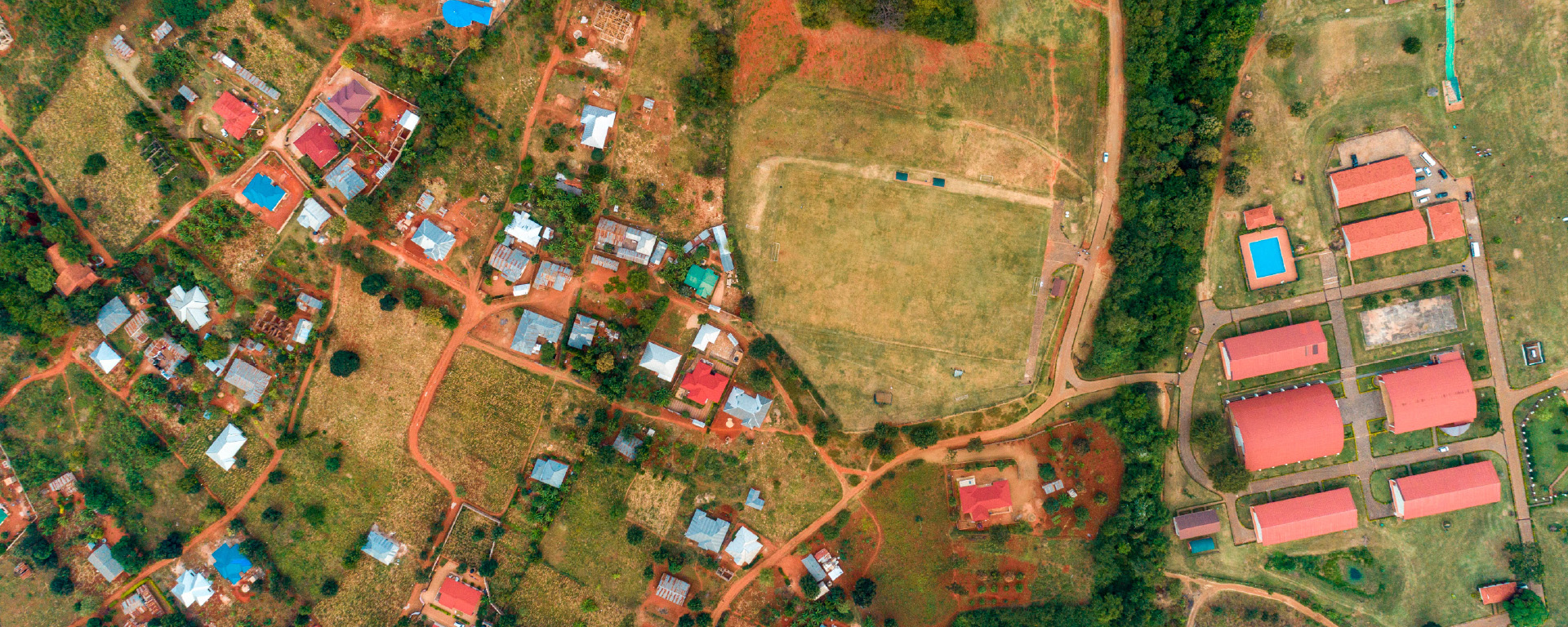
Image showing the aerial view of a vacant land in the context of a neighborhood settlement in Ambawadi, Ahmedabad. Source: Author

Research Method

 The larger research aims to propose typologically addressed NBS that relate to the context of Ahmedabad’s normalization to provide solutions that can be used to integrate ecologically RESEARCH PAPER steps involve merging the RGB bands into a single dataset, sensitive development, enabling a nature-integrated environment concerning the vacant lands. It does so by acknowledging the thematic concern of water-urban flooding and related challenges. In order to propose a larger framework as a potential matrix of possible NBS, there is a critical need to rank the vacant lands in the city that need a prioritized approach and representation to schematically identify scalable NBS. Thus, this research article unfolds a GIS-based method to analyze a grid schema that ranks different factors on a suitable weightage that spatially recognizes the critical spots in the city of Ahmedabad, having a higher risk of flooding, wherein NBS could be critically implemented. The method through GIS is described in the following sections in order to determine an overall gridded chart for Ahmedabad’s context.
 

GIS Methodology

I. Sourcing base layers for mapping the grid: The mapping involves sourcing of base layers to identify and classify land use. This helps in segregating the vacant lands from other supporting layers like built density, vegetation on ground, farmlands, and water bodies. Similarly, for the case of typology and contour levels, DEM data from the NRSC portal were obtained to develop the stream order and flood potential areas in the city. To support the study with the flood-prone areas as reported from sources, ICLEI’s Ahmedabad report has been considered to derive this layer. It pins the points where frequent f looding has been reported, that is primary for the study to understand the criticality of vacant lands in the context of various neighborhoods from a city scale perspective.

Image showing the LISS - IV Data Bands of Spatial Resolution 5.94m x 5.94m (Source: Author, NRSC Bhuvan Portal)

II. Band classification of the layers: For the base layers, a supervised image classification technique has been adopted to classify the bands from satellite data. LISS – IV datasets with a resolution of 5.8mx5.8m have been acquired from the NRSC - Bhoonidhi portal. The further steps involve merging the RGB bands into a single dataset, providing a combined raster. The raster is then used for spectral band splitting that can be used for land use cover.

Training samples were specified for each category of the required classification, namely vacant lands, vegetation, built density, water bodies, and roads. Each training involved roughly 15 samples to feed in the accurate depictions of the land use classifications. Through a supervised image classification of the base layer, different sets of split raster were then obtained in GIS. After the correction of the base layers through manual reclassification, the layers for analysis were finalized.

 III. Limitations with respect to base layers 

 a. The exhaustive list of vacant lands in the city based on ownership status was not publicly available to source to directly apply the grid weightage. For this, a supervised image-based classification technique was considered.

b. Since the derivation of land use has been a supervised image classification, the data obtained would not be highly accurate to the boundaries of the plot, but approximates the grid size that it falls under. This also accounts for further considerations that have been applied, wherein parks and gardens that are publicly owned by AMC have been removed from the primary layer of vacant lands, as it is not under the purview of the research study.

c. From the provided sources and documentation available, the typology has only been able to cater to the western part of Ahmedabad as represented. As the typology schematics would remain the same for the entire city of Ahmedabad, further data into the research can be plugged in for other typology considerations.

Image depicting the grid study methodology through GIS methods and limitations w.r.t. raster calculations for spatial ranking from point to raster (Source: Author, Esri ArcPro)

 IV. Overlays

With respect to a grid-specific approach other layers are also considered to identify the criticality of the vacant lands and specific typologies that it falls under. Flood points from contour data are identified to consider the spots under stress of flooding based on the topology. This layer is also verified with respect to the stream order lines that denote the higher order levels to be prioritized for criticality.

  1. The flood points as reported to the complaint cell and government offices are also considered to develop a ground status consideration of the issues within Ahmedabad. This helps in verification of the topological factors or in some cases, it adds up the flood prone conditions that may not have been realized only due to the contours derived from DEM.
  2. Built density has been considered as a high/medium/ low classification as it determines the relationship between the vacant land and the neighboring density. This also helps in considering specific NBS that would be relative to the criticality of vacant land.
  3. Roads and impervious surfaces are classified to determine the capacity that the specific grid can hold NBS for. For instance, if a higher order impervious surface is present, the scale and the NBS technique would change accordingly.
  4. Vegetation and farmland considerations are made to determine the relative absorption that the grid can percolate within. In this case the higher order vegetation in a grid would require considerably small scaled NBS or rather the criticality remains considerably low.
  5. Water bodies and wetlands are considered to allow the flow of water within the grid (a dissolve radius of 2.5km is also considered to consider the impact around the region), this would allow the vacant lands to have a low order of criticality as the flood plain would be directed to these bodies and would thus require minimal intervention. However, protecting and restoring NBS would be critical for this scenario.

 V. Grid analysis of the Layers

For the calculation of weighted spots in the city that would mark the criticality of the vacant lands, a grid-based technique was considered. The grid cells are fixed to 1kmx1km and are divided across Ahmedabad’s AUDA limits. The areas calculated from the raster layers were individually classified as points under each grid. Based on the number of points that each of the grids have been incurred with, the cells are ranked accordingly. The gradation thereby gives a city level classification of individual layers depicting hotspots.
 

Weighted Overlay Ranking chart for identified layers

VI. Grid Ranking and cumulative analysis

To run a rank-based simulation to support the criticality of the vacant lands, the grid is used to mark values for each layer. This allows a method to analyze a relative grading of layers that can depict the relationship of which layer accounts to the ranking that the cells would depict in the map. The below chart indicates the ranking values that would sum up to a given tally, while each cell representing the typologies would be a depiction of the vacant land’s criticality.

The layers are split into two categories:

  1. Roads, built density, contour factor and flood-prone points that have been ranked to give a sense of critical sites as typologies within the city that have been affected, while
  2. Vegetation and water bodies that can contribute as potential spaces that can be conducive of letting water to percolate at higher infiltration rates.

So, the relative grading of each cell out of the weighted score of 10 would indicate the relationship with vacant lands (removed layer from public parks and gardens to only allow the consideration of unaltered- public lands). The ranking allows a graded understanding of the typical conditions that vacant lands are positioned at, and their relevance within the context of other parameters as listed under the various layers. 

The grid analysis thereby gives a comprehensive ranking on the criticality of the vacant lands within various typologies and the need to accommodate necessary NBS that can further be plotted in the matrix (protect, create, restore) across various scales of intervention in further research.
 

GIS weightage-based ranking of all the cumulative layers. (Source: Author)
GIS weightage based ranking representation of the cumulative layers as

Conclusion

The research aimed at identifying critical conditions in Ahmedabad based on the identified thematic concern of urban flooding and its relation with the land-water continuum. The underlying factors were spatially demonstrated through GIS tools/processes by sourcing base/calculated layers that together overlay as a grid chart for the city of Ahmedabad. The cumulative map thereby demonstrates the hotspots in the city that are vulnerable to flooding and the prioritized need to adapt NbS. While the ranking charts represent the hotspots, it also indicates an overall understanding of the city w.r.t to the potential of the vacant lands as a typology within the public realm for adaptability.

While the current study primarily focuses on water and vacant land as typology, the methodology allows for multiple such cases for enquiries that can be modified within the proposed suitability matrix. This would allow for the possibility of various such plugins that can contribute to a wider applicability of NBS for cities.

In conclusion, NBS can be applicable to address various societal challenges in cities, while simultaneously delivering multiple environmental, economic, and social benefits if addressed locally through the considerations of urban context. In order to scale up the solutions on ground, there could be more comprehensive studies that can take into several climatic enquiries that could be addressed within cities. A framework through GIS methods as demonstrated in this article, provides key insights on how various factors can be compared and analyzed for a comprehensive matrix that promotes relative solutions and impacts. As a way forward, an adaptive management guide with possible matrix of applicable solutions would cater to all the involved stakeholders to be able to engage with the implementation of NBS.
 

References

Alexandre Chausson, B. T. (2020). Mapping the effectiveness of nature-based solutions for climate change adaptation. Wiley Online Library, 22.

Anuradha Mathur, D. d. (2014). Design in the terrain of water. Applied Research + Design Publishing with the University of Pennsylvania, School of Design.

Bélanger, P. (2009). Landscape As Infrastructure. Landscape  Journal. 28. 79-95. https://doi.org/10.3368/lj.28.1.79. Candiracci, S. L. (2022). Nature-based Play: Fostering connections for children’s wellbeing and climate resilience. London: Arup.

Coent, P. L. (2021). Is-it worth investing in NBS aiming at reducing water risks? Insights from the economic assessment of three European case studies. Science Direct .

Cunha, D. d. (2018). The invention of rivers: Alexander’s eye and Gange’s descent . University of Pennsylvania Press. Flavio Sciaraffia, S. K. (2019). From the South: Global Perspectives on Landscape and Territory. ediciones universidad del desarrollo.

Frantzeskaki, N. (2019). Seven lessons for planning nature based solutions in cities. Environmental Science & Policy, 93, 111.

Mahreen Matto, S. J. (2018). Water Sensitive Urban Design and Planning. Center for Science and Environment. Mahua Mukherjee, D. W. (2022). Nature-Based Resilience: Experiences of Five Cities from. International Journal of Environmental Research and Public Health, 25.

Mukherjee, M. (2022). Nature-Based Resilience: Experiences of Five Cities from South Asia. International Journal of Environmental Research and Public Health(Second Edition of Urban Disaster Resilience and Sustainability), 25.

 Nideroest, T. (2018). When the Only Water Left is Gray: The Understanding of Landscape as a Framework and Medium to Approach Water Scarcity. Landsc. Archit. Front.(The Growing Quest for Foreign Watersheds.), 7.

Shastri, P. (2023, July 17). Endless summer? Amdavadis feel the heat on 331 of 365 days. Ahmedabad, Ahmedabad, India. Siman, K. (2021). Nature-based Solutions for Climate Change Mitigation: Challenges and Opportunities for the ASEAN Region. UN Climate Change Conference, 36.

Sourav K. Biswas, P. R. (2019). THE SPONGE HANDBOOK: Using the Landscape Approach to transform the South Buckingham Canal Area. Chennai: GIZ.

Southern Regional Assembly, B.g. (2022). Blue Green Infrastructure and Nature-based Solutions Framework. ARUP. RESEARCH PAPER Stephan Pauleit, T. Z. (2017). Nature-Based Solutions and Climate Change – Four Shades of Green. SpringerLink, Theory and Practice of Urban Sustainability Transitions book series, 337.

Steven Windhager, F. S. (2010). Emerging Landscapes: Toward Ecosystem Services as a Basis for Design. Landscape Journal, 29(2), 107–123.

Wall, A. (1999). “Programming the Urban Surface,” 234 249. James Corner, ed. Recovering Landscape, Essays in Contemporary. New York: Princeton Architectural Press.

 

To download the PDF version of this article, click the button below.

Download PDF
  • GIS for Agri-Resilience

    GIS for Agri-Resilience

    India is one of the major players in the agriculture sector worldwide, and it is the primary source of livelihood for ~45% of the country’s population. The sector plays a major role in supporting livelihoods and ensuring food security for millions.

  • HARSAC Harvests Success: Groundbreaking  Agri Reforms Mapped with ArcGIS

    HARSAC Harvests Success: Groundbreaking Agri Reforms Mapped with ArcGIS

    Haryana Space Applications Centre (HARSAC) has developed and deployed a Geospatial Technology-based Crop Management Solution to address challenges in agricultural management.

  • GIS in education

    Technology-enabled Agriculture Education: UAS, Raichur

    The mission of the University of Agricultural Sciences (UAS), Raichur is to generate quality human resources in the area of agriculture and allied disciplines, generate cutting-edge competitive technologies.

  • Enabling Suez to Achieve Optimum Efficiency in Water Projects

    Enabling Suez to Achieve Optimum Efficiency in Water Projects

    Suez Group has been active in the Indian water and wastewater market since 1978 and established an Indian subsidiary in 1986. Suez uses Esri products to enable comprehensive study and planning through GIS mapping, field surveys, and door-to-door surveys.

Previous
Next