
Land Use and Environmental Change Analysis Using ArcGIS
Ankit Singh
Project 1: Land Use / Land Cover Classification of Haryana
Objectives
The overall objective for these steps is to analyze and understand the changes in land cover over time in the state of Haryana. This analysis can provide valuable information for land use planning, natural resource management, and environmental conservation. By collecting, pre processing, classifying, and analyzing satellite imagery, we can identify changes in land cover, evaluate their extent and impact, and create useful maps using ArcGIS.
Satellite | Sensor | Data of Pass | Path | Row | No. of Bands |
Landsat 5 | TM | 15-10-1992 | 147 | 040 | 7 |
Landsat 5 | TM | 18-11-2008 | 147 | 040 | 7 |
Landsat 8 | OLI/TIRS | 20-10-2022 | 147 | 040 | 11 |
Land Use / Land Cover During 1992

Land Use / Land Cover During 2008

Land Use / Land Cover During 2022

Land Use / Land Cover Analysis (1992 – 2022)
Methodology
- Data Acquisition: The first step is to acquire the necessary satellite imagery for the project.
- Image Preprocessing: The acquired satellite imagery needs to be preprocessed to correct any errors or distortions in the data.
- Image Enhancement: The preprocessed imagery is then enhanced using various techniques like contrast stretching, histogram equalization, and other enhancement techniques to make the objects of interest more visible.
- Feature Selection: Next, we select the features to be used for the classification. These features can include spectral bands, vegetation indices, and texture measures.
- Training Data Collection: We collect training data for each class of interest. This involves identifying representative areas of each class and labeling them accordingly. The number of training samples should be sufficient to capture the spectral variability of each class.
- Classification: Using the training data, we perform the classification. We can use various techniques for classification, such as Maximum Likelihood, Random Forest, and Support Vector Machines
- Accuracy Assessment: Finally, we assess the accuracy of the classification by comparing the classified map to referenced data.
- Mapping and visualization: We would create maps and visualizations of the land cover data and the results of the analyses.

ArcGIS Tools and Software Used
- ArcGIS Pro
- ArcGIS Spatial Analyst
- Image Classification Wizard
- Raster Calculator
- ArcMap (legacy steps)
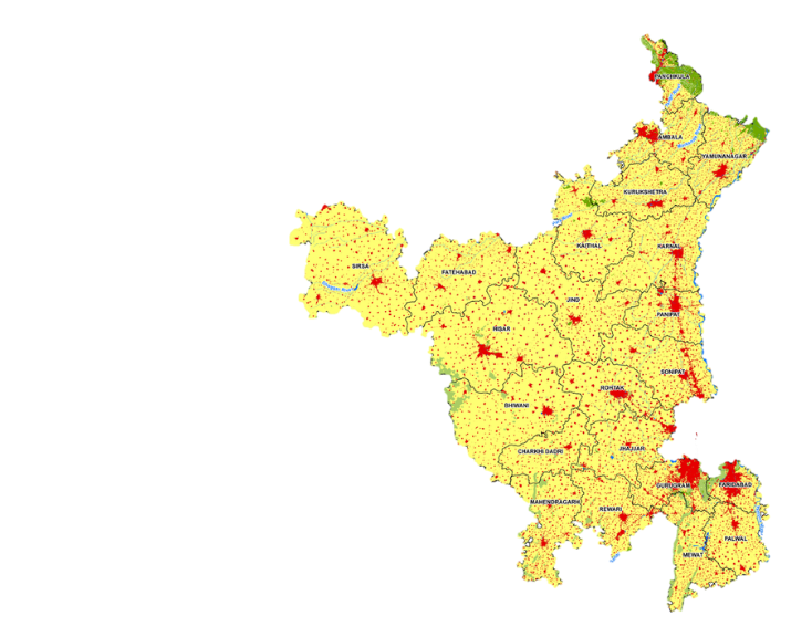
Haryana LULC Change Analysis
Comparison of LULC changes from 1992 to 2022 shows urban expansion and reduction in agricultural areas.
Project 2: Environmental Impact Assessment (EIA) - A GIS and Remote Sensing Based Approach
Why EIA is Important in India
- The development of GIS for EIA requires the analysis of this process in order to identify the tasks that will be beneficial.
- Broadly the objectives Of EIA is to estimate Impact of any developmental project / activity on the various Environmental components.

Topographical Map (Source: Survey of India and SRTM)
- Hills
- Rivers & Streams
- Contour
- Roads
- Habitation
- Railways
- Forests
- Administrative Boundaries

Drainage Map (Source: Survey of India and SRTM)
- Rivers & Streams
- Contour
- Hill shade
- Terrain

Land Use / Land Cover (SOURCE: Satellite Imagery, Survey of India and SRTM)

Project 3: Land Use / Land Cover Classification of Coal Block
Objectives
To study land use patterns between 2020 and 2023, utilizing LISS 4 imagery, to provide updated insights for informed decision-making.

Why Land Use Land Cover study is important
This thorough study not meets environmental standards but also aims to promote sustainability by:
- Community Livelihood (Residing Area)
- Resilience to Climate Change
- Positive Social Impact
False Colour Composite: IRS Resourcesat-2A


