

Site Scan for ArcGIS
A complete drone mapping software fully hosted on India cloud.
Drone Mapping, Simplified!
Complete drone mapping software in the cloud
- Plan drone flights in 3D
- Process in the India cloud
- Drone analytics
- Quickly share data
- Enterprise fleet management
- Advanced analysis in ArcGIS
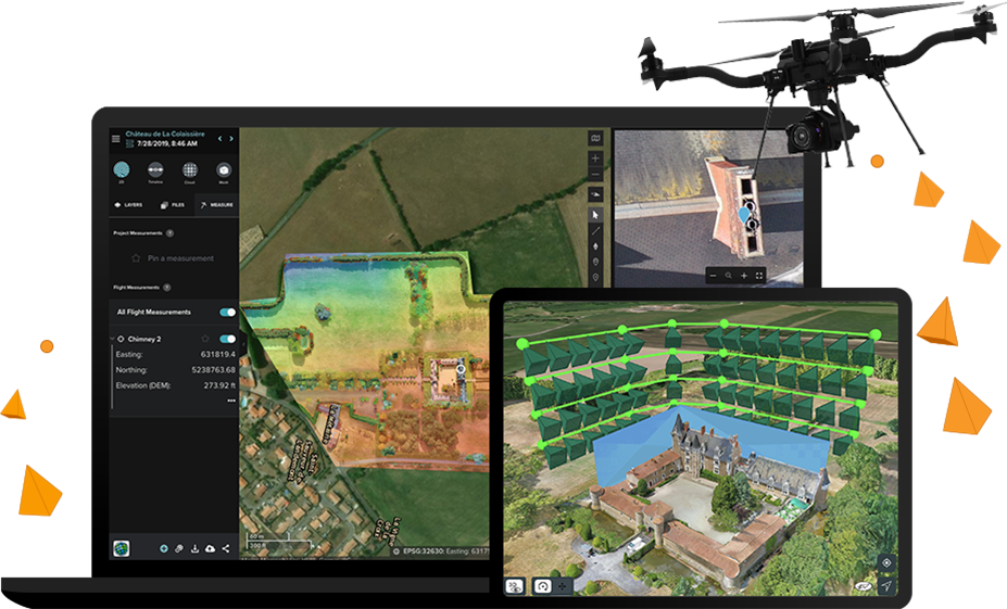
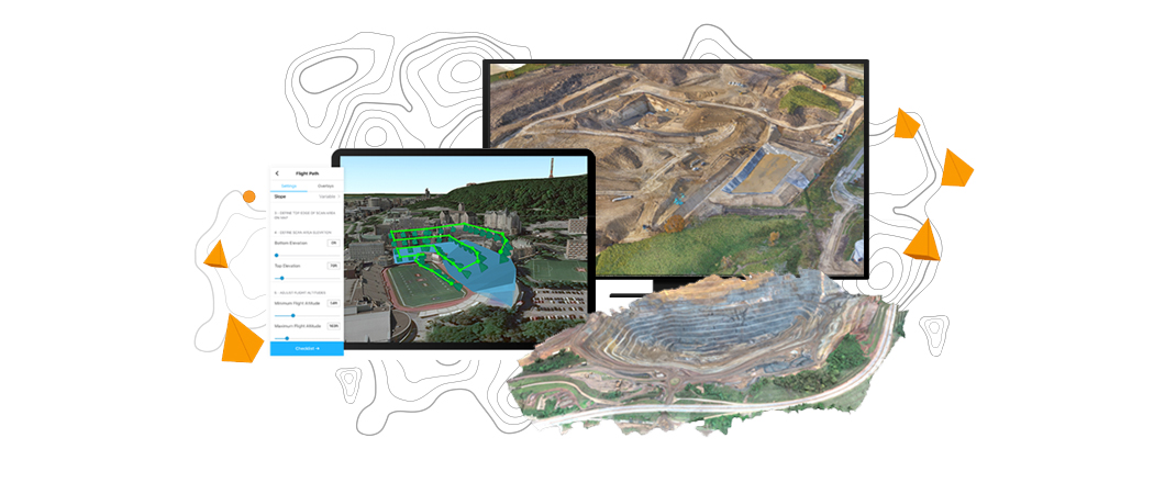
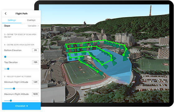
Plan autonomous drone flights in 3D
Increase efficiency by creating and sharing advanced 3D flight plans with your pilots. Overlay 2D and 3D data from ArcGIS Enterprise for enhanced flight safety and data quality. Manage your data in the field and upload it to the cloud.
Process and analyze in the India cloud
Unlimited amounts of drone flight data are processed into 2D and 3D outputs through a scalable cloud environment hosted in India. High accuracy is ensured through automatic ground control point detection. Easily visualize and analyze results directly in a web browser.
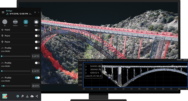
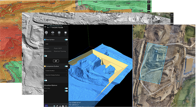
Drone analytics
Perform drone analytics by measuring distances, surface areas, and volumetrics; conducting temporal analysis; generating cut/fill maps; and measuring change over time. Maintain quality control by comparing your drone data to design overlays—including those in your Autodesk cloud environment—or compare it to drone data captured earlier in the project.
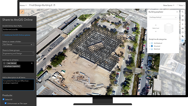
Quickly share drone and project data
Share information with your stakeholders in formats they understand, whether in a 3D view, as a report, or as a map to ArcGIS Enterprise; invite read-only users to analyze data in Site Scan Manager for ArcGIS; share content and report issues within Autodesk BIM 360; or export in common file formats.
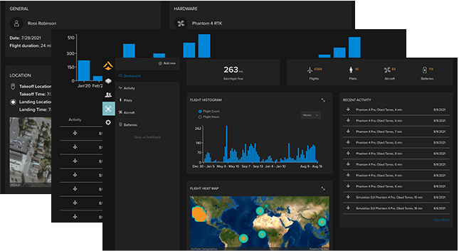
Enterprise fleet management
Fleet management keeps track of flights, drone hardware, and pilot flight history—all in one place. Drone program managers can create custom preflight checklists for their teams and store responses in the cloud.
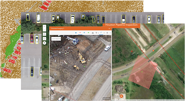
Advanced data analysis in ArcGIS
With the press of a button, Site Scan aerial photogrammetry data is available throughout the ArcGIS system, on-premises or in the cloud, to perform and automate advanced analytics such as object detection with ArcGIS Image Analyst. Easily integrate your drone imagery with building information modeling (BIM), lidar data, real-time Internet of Things (IoT) data, and more.
How it works

Plan
Plan the optimal flight path. For enhanced safety and planning accuracy, import layers and 3D models from previous flights.
Execute autonomous flight
Complete your preflight checklist and execute an autonomous drone flight.
Upload and process in the cloud
After the flight is complete, upload your data for cloud processing and mark ground control points manually or automatically using computer vision.
Visualize, analyze, and share
View 2D and 3D outputs on the web. Make measurements, track changes, and perform other analyses. Invite your team to view project data and results.
Publish content and perform advanced analysis
Export in formats you need, publish to your ArcGIS organization for advanced analysis such as deep learning workflows, or push to Autodesk BIM 360.
Drone mapping applications
Previous
Next

Works with ArcGIS
Site Scan for ArcGIS is a comprehensive drone software solution that you can use with ArcGIS Enterprise data.
ArcGIS Online
ArcGIS Online
Import your organization's saved GIS data and share your data with your ArcGIS Online organization for further analysis and collaboration.
ArcGIS Enterprise
ArcGIS Enterprise
Import your saved GIS data and share it in your ArcGIS Enterprise portal for analysis and collaboration.
ArcGIS QuickCapture
ArcGIS QuickCapture
Use ArcGIS QuickCapture together with Site Scan for ArcGIS to capture features remotely using the drone's location.
ArcGIS Drone2Map
ArcGIS Drone2Map
If working in an offline environment, use the Site Scan for ArcGIS Limited Edition iOS app to connect with ArcGIS Drone2Map and process, analyze, and export your drone data.
Contact us to get started
Join our growing list of interested users and organizations.
Get in touch with us
Product Information
Get answers for your product, industry or technical inquiries
Contact Us
Share your details with us
Give us a call
Talk over the phone