Field operations optimization
Empower field staff and citizen scientists to view and collect mission-critical data directly from their mobile devices.
SUCCESS STORY
In a world of accelerating change, especially when it comes to the climate, we are exposing ourselves to unnecessary risk. That is why Esri and the United States Geological Survey (USGS) led an innovative public-private partnership to create the Ecological Marine Units (EMUs), a 3D representation of the world’s oceans.
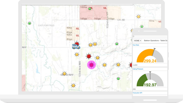
Connect your field data collection staff with the office. Give your entire team access to the same authoritative data to reduce errors, boost productivity, and save money.
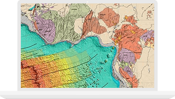
Use intuitive 2D and 3D mapping to create visualizations, perform complex scientific analysis, conduct image processing, and improve data management and integration.

Combine authoritative maps with narrative text, images, and multimedia content. Easily harness the power of maps and geography to tell your story.
Please fill out your details below for us to contact you for the demo.
Write to us at info@esri.in
Talk to us over the phone