
ArcGIS for Drone Data Processing and Analysis
June 29, 2023 | 11 am IST onwards
ArcGIS for Drone Data Processing and Analysis
Drone Data Processing and Analysis, provided by ESRI, is an innovative platform that allows organizations and professionals to process and analyse drone-acquired data efficiently. This solution enables users to derive valuable geospatial insights and make informed decisions by leveraging high-resolution aerial imagery. With the rapid advancement of drone technology, aerial data acquisition has become more accessible and cost-effective. However, the real value lies in extracting meaningful information from the vast amount of imagery collected. ArcGIS for Drone Data Processing bridges this gap by offering robust tools and capabilities to transform raw drone data into actionable geospatial information.
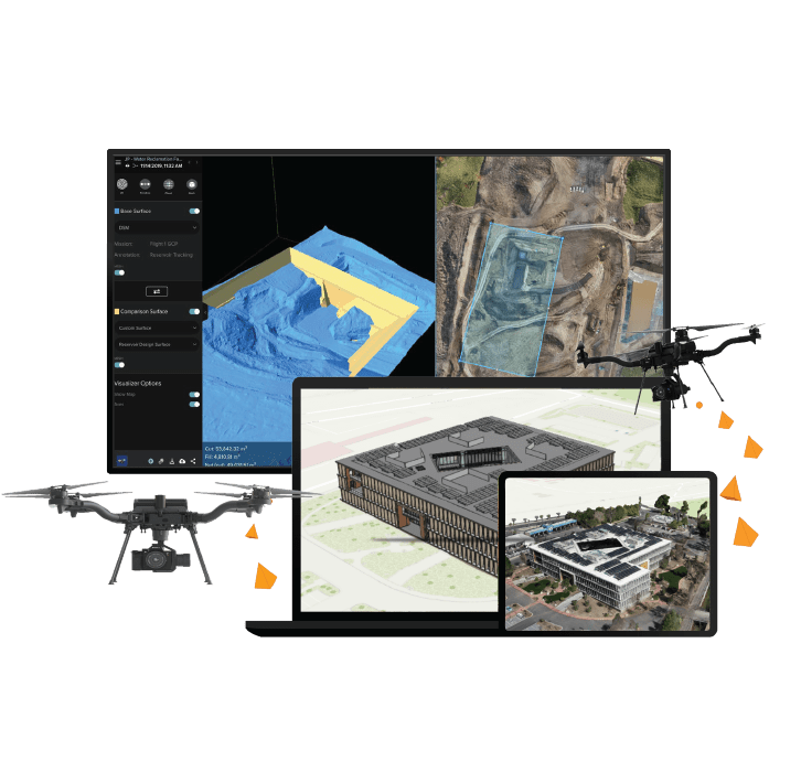
ESRI's platform represents a revolutionary advancement in geospatial analysis. It empowers users to seamlessly process and analyse data captured by drones, unlocking the untapped potential within aerial imagery. Advanced features like orthorectification achieve precise scale accuracy, while mosaicking seamlessly blends images for a comprehensive view. These capabilities ensure accurate geospatial data and enhance visualization and analysis. The platform also includes a suite of advanced analytical tools, such as terrain analysis, 3D modelling, object detection, change detection, and volumetric calculations. These tools enable users to extract valuable insights from drone imagery, ranging from identifying land cover changes to measuring stockpile volumes. By integrating drone data with other geospatial datasets, users comprehensively understand the spatial context and make data-driven decisions.
Drone Data Processing modules provides a user-friendly interface and workflow, simplifying data processing and analysis tasks. Users can easily import drone imagery, perform adjustments and corrections, apply analytical tools, and visualize results intuitively. This user-centric approach caters to both experienced GIS professionals and those with limited technical expertise.
To outline, ArcGIS for Drone Data Processing and Analysis is a cutting-edge solution that empowers organizations and professionals to process and analyse drone-acquired data effectively. This platform revolutionises geospatial analysis by bridging the gap between data acquisition and actionable intelligence, enabling data-driven decision-making and optimized outcomes across various industries.
Key Takeaways
- Seamless import of drone imagery and other geospatial datasets into ArcGIS.
- Accurate and visually appealing representations.
- Advanced analytical capabilities: Wide range of analytical tools, including object detection, change detection, and land cover classification.
- Extract meaningful insights from drone imagery for informed decision-making.
- Seamless integration with the ArcGIS ecosystem.
- Collaboration, sharing of results, and combining drone data with other spatial information layers.
- Industry applications.
Who should attend?
Professionals from diverse industries, such as construction, mining, transportation, utilities, agriculture, and government organizations. If you are engaged in site surveying, infrastructure monitoring, asset management, crop assessment, or planning and compliance, this session provides invaluable insights on utilizing drone mapping for your specific field.
Join us to discover how drone mapping can revolutionize your work and gain valuable knowledge tailored to your industry.
Speaker

Mallesh Ballina,
Esri India